Land Navigation AID with GPS using your smartphone
Land Navigation AID with GPS using your smartphone
The official app & game
Distributed by UptoPlay
SCREENSHOTS
DESCRIPTION
Use UptoPlay to play online the game Land Navigation AID with GPS using your smartphone.
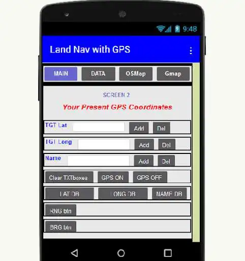
LAND NAV AID! Use this app to guide you to your destination location no matter if you are looking for your campsite, your fishing spot, your hunting spot, etc. You could also use it to find your FOB, your OP, your Rally Point, etc. if you were inclined to do so. It will provide you with the range and bearing to the destination locations from where you are now located. Accuracy is dependent upon GPS signal quality and smartphone receiver quality. Field tests have shown it to be quite accurate! Latitude, Longitude, and Name databases are provided to record GPS locations. Upon app startup, you need to press the GPS ON button on the DATA screen to show your present GPS location. You can save this GPS location and name it or you can press the GPS off button and the Clear Textboxes button. This will allow you to enter the GPS latitude, longitude, and Name of one of your saved GPS locations and calculate the range and bearing to it. An OSMap screen is provided to allow you to quickly plot multiple GPS coordinates by pressing the Map It button on this screen. This should be done with the GPS button in the DATA screen pressed in the off position. Also, the Gmap button will take you to GMap screen where you can press TGT L and L (latitude and longitude) and the Google Map TGT location button. This will locate the teardrop map icon to the database GPS coordinates or the GPS coordinates you have entered in the DATA screen. Once again, press the GPS off button in the DATA screen first. You can calculate the range and bearing of an unknown GPS coordinate directly in the DATA screen by first pressing the GPS ON button and then press the GPS off button. Press the Clear TXTboxes button and then enter the TGT Lat and TGT Long GPS data. Once this is done, press the RNG button and the BRG button to calculate the range and bearing to the target. Additionally, in the event of a SHTF scenario, with this app you can store the GPS coordinates of your BUGOUT and the coordinates of your home, your place of work, your school, etc. You can then use this app to calculate the direction and distance to these locations. Should the SHTF event occur, at least you will have an idea of where these locations are now compared to your present GPS position. As long as GPS remains active, you will have some idea of how to get to where you may need to relocate to. Should GPS go down, (Remember, the military owns it!) and you have stored this data in your billfold or purse, etc., with some rudimentary skills, such as how to use a magnetic compass, you could still find your way to a secure location. The creator of this app assumes NO LIABILITY for the use or misuse of this application!
Enjoy with UptoPlay the online game Land Navigation AID with GPS using your smartphone.
ADDITIONAL INFORMATION
Developer: Ranger Ron
Genre: Maps & Navigation
App version: 1.0
App size: 5.0M
Comments:
It gives your present position in latitude & longitude. There is no setting to enter a destination or to change coordinates to UTM. A waste of time.'
Page navigation:

